
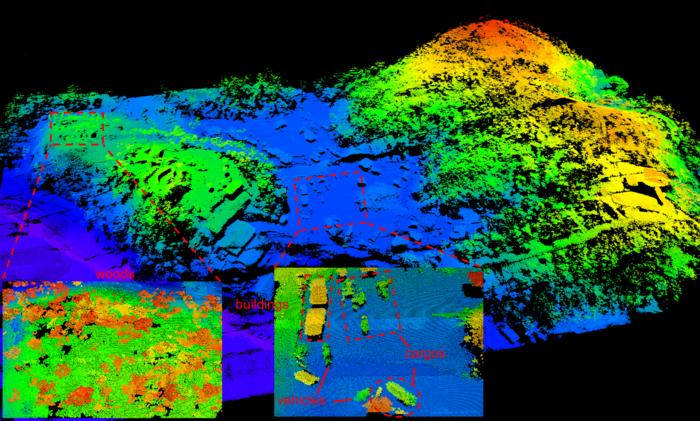
It achieves resolution better than 40cm from 2.1km altitude using around two photons per pixel, in the face of 10,000 daylight noise photons per pixel.
Created by the University of Science and Technology of China, the lidar combines three 150mA 1.55μm lasers shining 1ns pulses onto the ground through their own telescopes. Reflections are directed back to three 64 x 64 InGaAs/InP SPAD (single-photon avalanche diode) arrays, chosen because SPAD sensitivity allows low-power lasers to be used, and compensates for the narrow telescopes (aperture = 47mm) needed to keep size down.
Across the direction of flight, the beam width is 3 x 5.12mrad, or about 30m wide on the ground as the aircraft flys along. GPS and an inertial measurement unit within the chair-sized proof-of-concept provide sufficient data for these long narrow scans to be stitched together side-by-side to create a broad image of the ground.
As the fixed components above to not have sufficient resolution, the three lasers are deflected by a moving common mirror that is manipulated so that it both compensates for aircraft movement and scans the pixels across the ground.
“A key part of the system is the special scanning mirrors that perform continuous fine scanning, capturing sub-pixel information of the ground targets,” said team researcher Feihu Xu. “A new photon-efficient computational algorithm extracts this sub-pixel information from a small number of raw photon detections, enabling the reconstruction of super-resolution 3D images despite the challenges posed by weak signals and strong solar noise.”
In static ground tests, natural resolution was 15cm at 1.5km, increasing to 6cm once sub-pixel scanning and 3D deconvolution was implemented.
Already the lidar “enables highly accurate 3D mapping of terrain and objects even in challenging environments such as dense vegetation or urban areas”, according to the university.
The next step is to enhance performance and shrink packaging to the point that the lidar can be used on a spacecraft.
University of Science and Technology of China, at Hefei and Shanghai, worked with Hangzhou Institute for Advanced Study and the Shanghai Institute of Technical Physics.
Results are described in the paper ‘Airborne single-photon lidar towards a small-sized and low-power payload‘, published in Optica – The whole paper can be read without payment – figure 5, showing plots of raw data against processed data and is worth a look.
Image credit: Feihu Xu, University of Science and Technology of China