
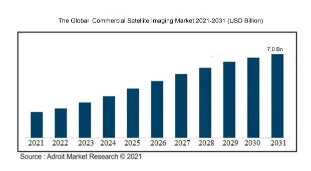
It calculates a CAGR of 7.6 % during 2021-2031. With the market for satellite imaging valued at $3.8bn in 2022, it will have doubled to reach a value of $7.0bn in 2031
As you would expect, North America dominates the market and accounts for the largest revenue share. Given geopolitical uncertainty, the report also identifies Military & Defence and Government as an increasingly valuable segment. Adroit writes:
“Furthermore, in the defence sector, the current terror threat and attacks on important infrastructure may be tracked using geographic mapping and defended using preventative measures.”
“Decision-making is becoming easier than ever before because to satellite imaging. Furthermore, satellite imagery aids mission planning, search and rescue operations, and the formulation of future improvements by providing exact mapping. As a result, the government and defence sectors have combined to become a major development driver for this industry.”
The base year for the report is 2022.
Application
The report considers the imaging market by region, by application type (geospatial data acquisition and mapping, natural resource management, surveillance and security, conservation and research, construction & development, disaster management, and defense & intelligence), by end use type (government, construction, transportation & logistics, military & defence, energy, forestry and agriculture, and Others),
The key companies profiled, says Adroit, include DigitalGlobe, Spaceknow, Harris Corporation, Planet Labs, BlackSky Global, Galileo Group, ImageSat International, European Space Imaging, UrtheCast and Maxar.
Growth
In terms of limitations on future satellite imaging growth, Adroit writes:
“The lack of awareness about market applications among the target audience is one of the primary restrictions on the market’s growth during the current projection period.”
“Furthermore, governments in various global locations have a tendency to enact shutter control policies that require foreign satellites that are a part of the territorial airspace to turn off imaging equipment in extreme and critical cases, causing the market to improve its operations and grow at a slower rate.”
You can access the report on commercial satellite imaging from the Adroit website.