
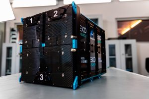
The 6U CubeSat, with its multispectral camera, will be capable of detecting wildfires, ship movements, and marine pollution, for example.
Having launched in August 2024 from the Vandenberg Space Force Base, nine months of commissioning followed, involving its imager and onboard AI applications. These AI capabilities, says ESA, include selecting images with clear visibility, while discarding images obscured by cloud cover, for example.
The algorithms can also detect and analyse disaster areas, whether wildfires, earthquakes or floods. And, as mentioned, it can gather data on illegal fishing and marine pollution. Basically, analyse and process imagery in real-time
The satellite generates images using seven multispectral bands. These range from visible to near-infrared, as well as one panchromatic band. It has a ground sampling distance of about 5m. It follows a sun-synchronous orbit at an altitude of 510km.
 What AI apps?

Specifically, Φsat-2 (pronounced PhiSat-2) was originally running four AI apps.
These comprise Sat2Map – developed by CGI – which sends critical data to response teams during emergencies and disasters such as floods and earthquakes. It uses the satellite imagery to create maps of affected areas for use by teams on the ground.
There is also Cloud Detection, which was Developed by KP Labs. This detects, identifies and classifies clouds to give real-time insights into cloud distribution.
The Vessel Detection app was developed by CEiiA to use machine learning to detect and classify vessels based on Phisat-2’s multispectral images.
Finally, Deep Image Compression is an app developed by GEO-K that compresses the images captured on board for more efficient transmission to Earth.
Two further apps were uploaded to the satellite once in orbit. The first is Anomalies in Marine Ecosystems. IRT Saint Exupéry Technical Research’s app uses machine learning to scan satellite imagery and spot anomalies in marine ecosystems. For example, characterising oil spills, algal blooms and sediment flooding.
The second is PhiFire AI. This is a wildfire detection app from Thales Alenia Space that sends early-warning signs to response teams on Earth.
Level 1 data?
ESA’s initial plan was to process data onboard and then transmit information generated by the AI applications back to Earth. But Nicola Melega, the ESA Earth observation system engineer responsible for commissioning Φsat-2, explained a change to share full data sets:
“As often happens, we realised during the commissioning phase that there were ways of making the mission more interesting for AI developers and instead of making available only the end results of the onboard processing chain (Level 2 data) we now provide users with an entire collection of Level 1 data products that will help the application development and the training process.”
Access to ESA’s PhiSat-2 mission data is available through CGI’s Insula platform.
Φsat-2’s AI capabilities allow for more data to be processed quickly and accurately, says the ESA. This will help transform vast amounts of raw data into actionable insights. By processing images directly in orbit, in theory, it can ensure that only clear, usable images are sent back to Earth.
The Φsat-2 mission is a collaboration between ESA and Open Cosmos, which serves as the prime contractor, supported by an industrial consortium including Ubotica, GGI, CEiiA, GEO-K, KP-Labs, and SIMERA.
The CubeSat was the successor, unsurprisingly, to Φsat-1 (also known as FSSCat), which tested on-board AI analysis between 2020 and 2021.
Demonstrator
Who is providing the ground segment for the mission? it is provided by Open Cosmos and CGI Italy. Kongsberg Satellite Services (KSAT) also provide a ground station service, mainly from antennas in Svalbard.
The ESA highlights that Φsat-2 is still a demonstrator mission, designed to find the limitations and gaps in new technology.
“But its purpose is also to build our understanding of the processes,” added Melega. “We can check the performance of the applications and we can also see what resources are needed to manage the mission and process the data.”
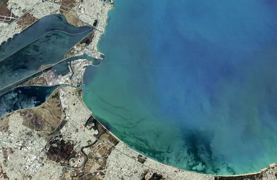
Images: Top: Φsat-2 view of the Gulf of Tunis, Tunisia. Bottom: Φsat-2
See also: ESA to launch AI satellite to show advances in Earth observation
FAQ
What AI apps are running on the Φsat-2 satellite?
Six AI apps have been identified:
- Sat2Map – developed by CGI – which sends critical data to response teams during emergencies and disasters such as floods and earthquakes. It uses the satellite imagery to create maps of affected areas for use by teams on the ground.
- Cloud Detection – developed by KP Labs. This detects, identifies and classifies clouds to give real-time insights into cloud distribution.
- Vessel Detection – developed by CEiiA to use machine learning to detect and classify vessels based on Phisat-2’s multispectral images.
- Deep Image Compression is an app developed by GEO-K that compresses the images captured on board for more efficient transmission to Earth.
- Anomalies in Marine Ecosystems – developed by IRT Saint Exupéry Technical Research, the app uses machine learning to scan satellite imagery and spot anomalies in marine ecosystems. For example, characterising oil spills, algal blooms and sediment flooding.
- PhiFire AI – developed by Thales Alenia Space. This is a wildfire detection app from Thales Alenia Space that sends early-warning signs to response teams on Earth.
What type of satellite is Φsat-2?
Φsat-2 is a 6U CubeSat
How does the satellite generate its imagery?
It generates images using seven multispectral bands.
What is the orbit of Φsat-2?
It follows a sun-synchronous orbit at an altitude of 510km.
When did the Φsat-1 satellite operate?
Φsat-1 (also known as FSSCat) tested on-board AI analysis between 2020 and 2021.