
This technology makes it possible to reliably measure sea levels, even in the event of a tsunami or ground movement at the location where the measuring equipment is installed.
Current radio wave and float-type sea level measurement systems have a measurement range of about 20 meters from the surface of the sea.
However, if ground movement occurs due to an earthquake or other phenomenon, it becomes difficult to measure sea levels.
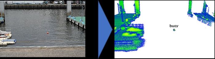
NEC’s technology delivers 3D-LiDAR infrared laser beams to buoys floating on the sea, and reflected light is used to measure the distance.
This ultra-sensitive optical reception is accomplished using long-range 3D-LiDAR with advanced long-range, large-capacity optical transmission and reception technology (coherent reception technology), making it possible to obtain the 3D point cloud data of objects from greater distances.
As a result, this is the first time that sea levels have been successfully measured from a distance of 60 meters from the sea with an error of about 2cm.
In addition, a 3D water level measurement technology has been developed that clusters processing of the acquired 3D point cloud data, classifies the shape of buoys and surrounding topography with high precision, and then compares the information to correct the position and estimate the height of buoys.
This makes it possible to measure from a variety of locations and angles, meaning that 3D-LiDAR equipment can be installed in a wider variety of locations.
 3D point
As a result, tide stations may be installed in locations along the coastline that are less susceptible to significant ground movement, making the system disaster-resistant and enabling continuous monitoring of sea levels.
In addition, the equipment is portable and may be flexibly installed across a wide range of locations, helping to reduce installation costs and time.