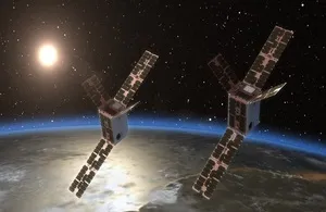
The Orpheus mission has two aims: to measure space weather and support Space Domain Awareness (SDA). Specifically, to characterise the ionosphere (the ionised portion of Earth’s upper atmosphere) And also to capture image data to support Space Domain Awareness.
Bath is working on the former, studying the differential phase of received GPS signals. This is both to better understand space weather and help improve GPS and communications technology.
The mission involves two identical CubeSat satellites observing and collecting data using in-situ and remote sensing techniques. They will be flying in formation, in Low Earth, Sun Synchronous Orbit.
Bath dubs the satellite payload TOPCAT II (Topside ionosphere Computer Assisted Tomography). It was created by Dr Robert Watson and Professor Cathryn Mitchell in Bath’s Department of Electronic & Electrical Engineering.
Measuring 9 x 7 cm, the payload features an advanced multi-frequency GPS receiver. This will estimate the total electron content of the ionosphere.
Essentially, the receiver will measure the electron content of different phases of GPS signals. This will help identify understand how signals change direction as they move through the atmosphere, which creates GPS errors.
The aim is to give scientists and engineers data to better understand space weather phenomena. And also help design resilient future satellites, the university adds.
Ionosphere
Understanding the characteristics of the dynamic ionosphere is vital for a range of both civil and defence applications, highlights Bath. For example, the Global Navigation Satellite System, communications, sensing technology and space sustainability.
“This is an exciting opportunity for us to have our space weather instrument on a satellite and to use the data in the University of Bath MIDAS imaging data assimilation, an advanced algorithm that gives us a highly accurate three-dimensional image of the Earth’s ionosphere and its evolution in time,” said Professor Mitchell.
Dstl
The work is part of the £5.15 million satellite contract from the UK Defence Science and Technology Laboratory.
Astroscale is leading the project. Also working with Astroscale are Open Cosmos, Dragonfly Aerospace, Surrey Satellite Technology and US Naval Research Laboratory.
The satellites are due to launch in 2027 and the three year contract will conclude in 2028.
Virgin Orbit
Why TOPCAT II? Orpheus is actually a successor to the CIRCE mission. This is where the first TOPCAT satellite payload headed to space. But the payload was lost aboard the Virgin Orbit launch from Spaceport Cornwall in Newquay, back in January 2023.
Unfortunately, the two-stage rocket, LauncherOne, wasn’t successful in reaching its required orbit.
Other satellites lost: a research pathfinder satellite from RHEA Group, the first Omani Earth-observation satellite, and Space Forge’s ForgeStar-0 CubeSat, the first ever Welsh satellite.
Image: NRL

